It seems that the approach for Mt Conness can be a bit confusing so here are some photos with the route we took on our way to climb the Harding Route on the Southwest Face. This is the more direct of the two approaches from Saddlebag Lake and supposedly is about 4.5 miles long with 2,500 feet of elevation gain. It took us around 3.5 hours a moderate pace with a few rests. It took another 30 minutes to descend from the summit plateau to the base of the route. On our way back it took less than two hours from the true summit to the car.
This approach starts at the Sawmill Campground (near Saddlebag Lake) and I believe is the shortest distance to the top of Conness. From the parking lot hike out the good trail/road through the campground passing sites for a while. At some point the trail will narrow a little but stays quite good all the way to the Carnegie Institute.
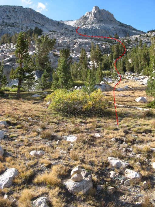
Looking up hill where we left the trail.
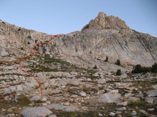
About 15 to 20 minutes past the Carnegie Wooden Shed we left the trail and started the cross country travel. There were a bunch of cairns on the right side of the trail marking the general area you leave the trail. The basic idea is to head up hill taking the easiest path towards the peak seen in the photo above and below. A bit of hiking will lead to a clearing and you should be able to see something similar to the first photo below.
Looking up at the ledges from the first flat spot.
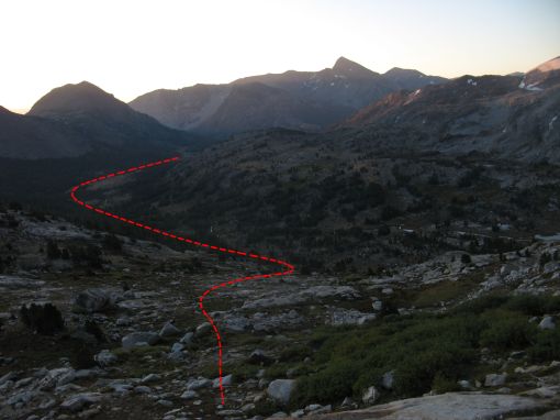
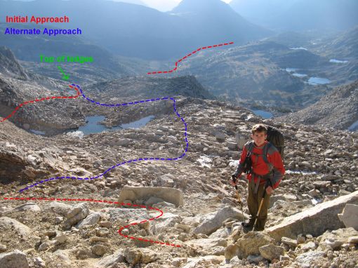
Looking back at the approach before going up the ledges.
Once you reach the large flattish clearing you will be need to go up and over a set of ledges on the left side. There should be a faint trail and possibly the occasional cairn. This set of ledges will lead you to another large flat area that should have a small lake (size depends on season). From here there seemed to be two options to gain the steep slope that leads to the summit plateau. On the way in we stayed north (the right side looking uphill) of the second and bigger lake and followed the red path in the photo below. This had us going along the ridge which was fine. On the way back we went on the other side of the big lake seen in blue below. Both paths met up in the meadow near the smaller lake and went over the 3rd class ledges in a photo seen above.
Looking down at the approach from the steep switchbacks
Our approach followed the ridge seen below to some steep switchbacks which ended at an obvious notch. While the switchback section was a bit steep there was a trail most of the way and you could tell this section had seen a bunch of traffic. It is pretty hard to get lost if you aim for the notch in the photo below.
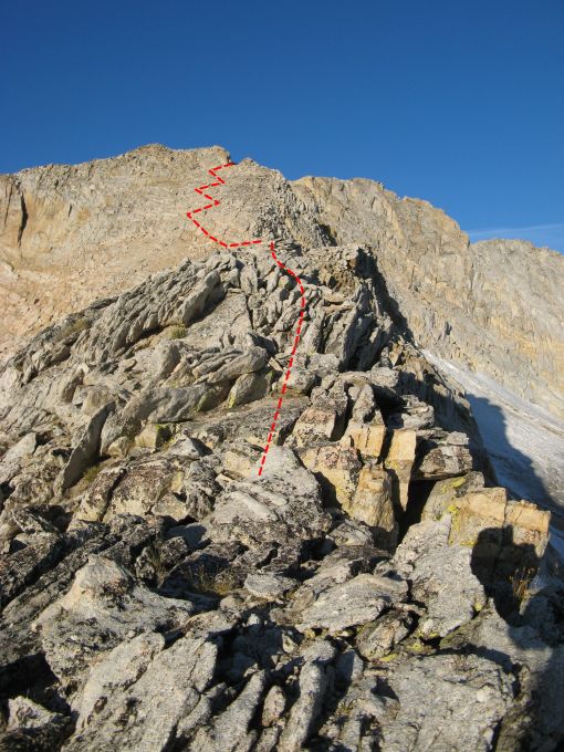
The very pretty ridge line with a steep drop on the right.
Below is another view of the ridge approach from the steep switchbacks. After gaining the notch at the top of the steep switchbacks you will be at a large plateau below the summit. This was the first time we could see the summit of Mount Conness from the approach. We had only previously seen the lower section of the North Ridge. Cross the sandy plateau and you should see a large cemented cairn and a few wind breaks with more cement and some USGS circular markers. This is where we left our packs and racked up for the climb.
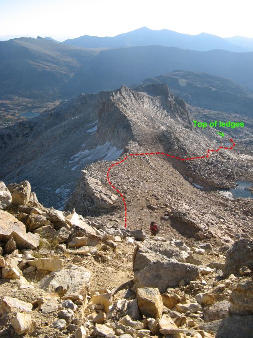
Almost to the notch after a bunch of sandy switchbacks.
From this point continue down to either the second or third gully (I don’t remember which). As noted in the Supertopo don’t go down too early since the first gullies cliff out. Also you should be able to see the SW face in full view from the top of the gully. There is a trail, that should not be followed, that keeps going down past the correct gully so if you go more than 5-10 mins from the edge of the sandy plateau you have gone too far. A few 3rd class sections lead to scree surfing and talus walking towards the Southwest face. The photo below was taken from the approach.
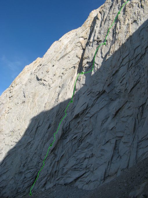
The First few pitches, as we climbed them, on the Harding route of Mt Conness.
As described in the Supertopo the route starts just right of a section of black rock which is often wet.
Good Luck!!
– Luke
[…] cut off across more rugged terrain. Since the approach seems a bit confusing I made an earlier post with photos showing how we hiked in. In no time we had passed the Carnegie Institute and were trying to […]
Can we assume that the whole point of all these ‘alternate’ approaches is to avoid going into the park? While slightly longer, the easy walk in via the Young Lakes trail involves little or no elev gain, puts you right at the base of the route and presents a pretty casual descent back to where you started (though we did the route in ’79 so apologies if that has not been the case for others).
Coming from the East Side (Hwy 395) it takes longer (driving wise) to go into the park. I also thought that the distance was a mile or two longer via Young Lakes. These directions are one of the super topo suggestions. I heard the Young Lakes beta was incorrect in the supertopo guide. I’ll have to go that way next time since I’m now in the Bay Area.