Mount Conness Approach Beta

21 09 2009

It seems that the approach for Mt Conness can be a bit confusing so here are some photos with the route we took on our way to climb the Harding Route on the Southwest Face. This is the more direct of the two approaches from Saddlebag Lake and supposedly is about 4.5 miles long with 2,500 feet of elevation gain. It took us around 3.5 hours a moderate pace with a few rests. It took another 30 minutes to descend from the summit plateau to the base of the route. On our way back it took less than two hours from the true summit to the car.

This approach starts at the Sawmill Campground (near Saddlebag Lake) and I believe is the shortest distance to the top of Conness. From the parking lot hike out the good trail/road through the campground passing sites for a while. At some point the trail will narrow a little but stays quite good all the way to the Carnegie Institute.

Approach

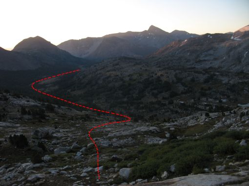
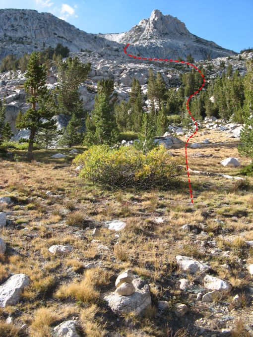
Looking up hill where we left the trail.

About 15 to 20 minutes past the Carnegie Wooden Shed we left the trail and started the cross country travel. There were a bunch of cairns on the right side of the trail marking the general area you leave the trail.  The basic idea is to head up hill taking the easiest path towards the peak seen in the photo above and below. A bit of hiking  will lead to a clearing and you should be able to see something similar to the first photo below.

ApproachA

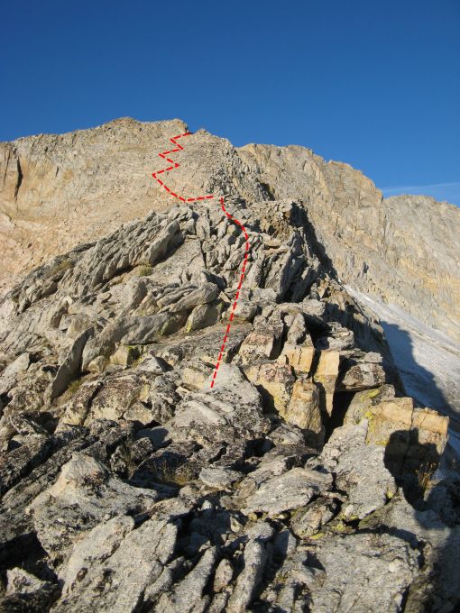
Looking up at the ledges from the first flat spot.

ApproachDown

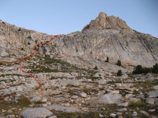
Looking back at the approach before going up the ledges.

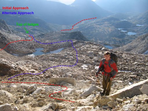
Once you reach the  large flattish clearing you will be need to go up and over a set of ledges on the left side. There should be a faint trail and possibly the occasional cairn. This set of ledges will lead you to another large flat area that should have a small lake (size depends on season).  From here there seemed to be two options to gain the steep slope that leads to the summit plateau.  On the way in we stayed north (the right side looking uphill)  of the second and bigger lake and followed the red path in the photo below. This had us going along the ridge which was fine. On the way back we went on the other side of the big lake seen in blue below. Both paths met up in the meadow near the smaller lake and went over the 3rd class ledges in a photo seen above.

ApproachDownE

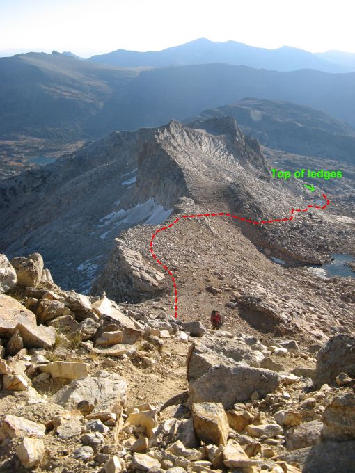
Looking down at the approach from the steep switchbacks

Our approach followed the ridge seen below to some steep switchbacks which ended at an obvious notch.  While the switchback section was a bit steep there was a trail most of the way and you could tell this section had seen a bunch of traffic. It is pretty hard to get lost if you aim for the notch in the photo below.
ApproachB

The very pretty ridge line with a steep drop on the right.

Below is another view of the ridge approach from the steep switchbacks.  After gaining the notch at the top of the steep switchbacks you will be at a large plateau below the summit. This was the first time we could see the summit of Mount Conness from the approach. We had only previously seen the lower section of the North Ridge. Cross the sandy plateau and you should see a large cemented cairn and a few wind breaks with more cement and some USGS circular markers. This is where we left our packs and racked up for the climb.
ApproachDownB2

Almost to the notch after a bunch of sandy switchbacks.

From this point continue down to either the  second or third gully (I don’t remember which).  As noted in the Supertopo don’t go down too early since the first gullies cliff out.  Also you should be able to see the SW face in full view from the top of the gully. There is a trail, that should not be followed, that keeps going down past the correct gully so if you go more than 5-10 mins from the edge of the sandy plateau you have gone too far.  A few 3rd class sections lead to scree surfing and talus walking towards the Southwest face.  The photo below was taken from the approach.

ConnessHardingRouteTopo

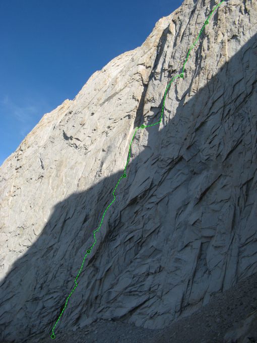
The First few pitches, as we climbed them, on the Harding route of Mt Conness.

As described in the Supertopo the route starts just right of a section of black rock which is often wet.

Good Luck!!

– Luke


Alone in Tuolumne.

10 09 2008

This past Friday was my day off so I drove up to Bishop to see Lizzy. She was in town for a resupply and we were able to have lunch and chat before she had to return to her field work. It was great to see her and sad when she got back in the CalTech Geology truck and drove off. We crunched lots of talking and hugging into our 4 hours together which was not close to enough. It was defiantly worth the drive to see the smile on her face when I pulled up.

With Lizzy quickly back to work I had decided to take some alone time. A partner hadn’t worked out but I hadn’t really tried that hard. I was looking forward to some personal reflection and a bit more exploration of Bishop and Tuolumne. I had brought along my bouldering pad so I could do a bit of pebble wrestling when I tired of hiking and driving. The 90+ degree forecast (in bishop) was not ideal but I managed two night sessions at Rock Creek.

Rock Creek is located near Tom’s Place about 25 miles north of Bishop on the Sherwin Plateau. Rock Creek is appeal since it is more than a thousand feet higher in elevation than the Buttermilks and is surrounded by shady trees. The boulders are located in canyon cut by the water so they receive shade a bit earlier than else where.

Before heading to Rock Creek on Friday night I drove up to Owens River Gorge and hiked down to see the climbs. I had never been to the gorge before and had been curious about the volcanic rock and feel of the area. There is climbing on both sides of the gorge and there is a road down the middle that provides access to the various power plants in the gorge (Only service vehicles are allowed in). I had a good time running around and checking out the climbs and am anxious to get back with a partner and rope. The climbs are long and vertical and mostly bolt protected. Since the river goes down the middle of the gorge you sometimes have to cross mini bridges to get between areas.

As the light was fading I was making my way around Rock Creek. The guide book showed a few boulders and I was looking for something hard with a nice landing. After exploring the Campground boulder I made my way to the talus boulder. I warmed up on a V2 and started trying One Move Blunder V4. The granite was rough and had some funky knobs. After gaining the crimp rail, on this V4, you were supposed to launch for the top of a huge (3 feet wide by 2 feet tall) feature. This “knob” unfortunately did not stick out much and was directly over a bad rocky landing. I oped for the bail out left option since dynoing without a spotter would not be a good way to start my trip. The Blunder Bus V6 is the bail right option that I did next.  The guide book said move right immediately after reaching the crimp rail. This seemed a bit contrived so I matched the crimp rail, which made the move longer but allowed me to use my feet, and then went right.

Next up was Clearcut a fun looking V7 on the arete that had very directional holds and bad feet. The crux was a standup move into a sharp V-slot with your left hand using a bad right hand crimp. I slowly figured out the beta and was able to do all the moves. I fell many times trying to link from the start and my skin was toast. It was about 8pm and quite dark so I called it a night. Tired from my 6am departure I made my way to my bivy in Tuolumne and ate a bit of dinner before passing out.

The next morning i got up before sunrise so that I could get out to the rocks quickly. I packed up and drove into Yosemite National Park, via the 120, and parked near Tenaya Lake. I was the first car in the parking lot and that meant I would be the first up Tenaya peak. The approach was easy with my small pack of water and climbing shoes. Most importantly I was able to find my way up the assorted Deer Trails and didn’t lose time getting lost. I did get a little confused about where I was supposed to start since there is no base to the southwest face. There are slabs that you are hiking up and at some point you decided you should start “climbing”. Not wanting to find my self in the middle of a tricky slab in my approach shoes I put on my Muiras and got out my chalk bag.

As I steadily went up more 4th class terrain I was worried that I was off route since it was so easy. I wanted to climb, but instead my calves were burning and I was breathing heavy from the altitude. A large band of dikes across the face that matched my topo, I was on the right track! Even though I was excited I couldn’t really pick up the pace since my lungs were suffering, I am not used to being above 9000 feet. The climbing was constantly easy and did not really necessitate a rope. Lizzy had pitched out the climb in her approach shoes and I was happy to be moving quickly.

I took a break on a ledge about half way up and ate some food and took off my climbing shoes. The view was spectacular and I had the whole place to myself! I summited a little over two hours after I left my car. The climbing took a bit more than the approach but it was very mellow. The top section required a bit more attention since the rock got a bit steeper. I got pretty lost on the decent and was more gripped going down loose gullies than climbing the route. It was about 3.5 hours car to car so I still had a full day ahead of me.

I ate lunch and relaxed at Tenaya Lake and gave a ride to a hiker from Murrieta named Bruce who had been in the area for the last few days enjoying the trails with his family. I wandered around Tuolumne and hiked to Drug dome and checked out OZ. I met a nice guy named Dennis who had been out photographing a pair of British climbers on the route. OZ looks spectacular with difficult face climbing followed by a 100+ foot long corner. After watching the couple go up the route I made my way over to Lamb Dome. Lizzy and I are interesting in doing On the Lamb, which traverses the dome, and I wanted to get my bearings. After finding the trails I made my way to the base and found a spectacular wall of knobs.

I went back to the car and grabbed my shoes and returned for a bit of traversing. I figured it would be good training to get used to the Tuolumne crimps and knobs and a fun way to spend my afternoon. I hopped on the wall and made my way most of the way across but was stopped by a reachy crux in the middle. It seemed that climbing higher might be the solution but since I was still along I decided to wait for another day. Exhausting my supertopo book for new places to go I stopped by the store and bought the Falcon guide. Tired of hiking I grabbed a vanilla soft serve and got back on the road. I needed to leave early enough to stop by Bridgeport, about 30 mins north of Tioga Pass, before going back to Rock Creek.

While I was unable to contact the ranger station, since their phone line is bad (according to the main office), I thought it was worth the trip to try and receive my rope. I made good time and luckily the station was still open and they had my rope! Sadly there was a pretty nasty core shot just beyond the middle mark on the rope. It was great that the two guys from Colorado hiked it out and I can still use the pieces once I cut it up.

I arrived at Rock Creek on Saturday night to cooler temperatures than the night before. As well I ran into a Swedish couple at the talus boulder. They were trying an improbable sit start that was not in the guide book. I had looked at it the night before but the holds seemed too poor. After warming up I spent a few minutes brushing the holds on Clearcut. I had found a tooth brush in my car and was very happy to have cleaner holds, better friction! I breathed in, pulled on, and sent first try! I was able to relax in the crux and get my weight over my left foot which allowed me to go statically to the sharp slot. After sending I did a standing jump variation of a V9 to the right. With a bad foot and two bad crimps you lunge to the top. This move was hard from a standing position and I couldn’t figure out how to do it from the sit (for the full points).

To finish off the last bit of daylight I went over to the Boy Named Sue boulder and climbed the Groove Arete, V4. By the time I had worked out the moves it was dark and I was using my headlamp. After I topped out I realized I was very alone and in the dark with no down climb. The climbs, on this boulder, range from V4 to V10 and evidently there is a V2 on one of the aretes. I couldn’t see the moves of the V2 and it did not seem logical to downclimb from 15 feet on an unknown problem with no pad. I tested a few of the near by trees and grabbed the biggest one and shimmeyed down. I bear hugged that tree like no other, palming my way down the smooth bark wishing there were branches. That was by far the scariest part of my weekend, worse than 1000 feet of climbing, harder than V7, down climbing the tree, alone, in the dark pushed my limits.

With my weekend project sent I drove back to Bishop and camped near the Buttermilks and had dinner. I slept like a log with a full day of walking and a bit of climbing behind me. On my way back to Bishop I tried to find the Catacombs where I was planning a morning session. Instead of going over the Dam I took a wrong turn and went 1.3 on a different dirt road. It was pitch black and when I got to the correct distance there was a fork like I expected. Unfortunately the fork was complete overgrown and I did not feel like exploring anymore so I bailed.

The next morning came quickly since I slept quite well but my skin and muscles were pretty trashed. I packed up the tent and headed back to San Diego content with my exploration and bouldering. It was pretty strange to be alone all weekend and I did get a bit used to the solitude. I listened to my Ipod and thought about how much I missed Lizzy. It was a good time for sure but I wont be making a habit of it.

In more exciting news Alex Honnold just Free-Soloed the Regular Route on Half Dome. Via Supertopo The big question in a lot of peoples minds is a free solo of El Cap. In an old supertopo thread there is a bunch of discussion about how many difficult parts of FreeRider are insecure and dangerous. I am glad to see Alex pushing the limits but I want to see him around for many years to come. Hopefully he can put his energy into freeing a new route on El Cap instead of risking death by free soloing it.

Cheers,

Luke


Sierra Suffering or: How I Learned to Stop Worrying and Love the Altitude

3 09 2008

After serious sport climbing for the past two weekends I needed a bit of break from small crimps and powerful moves. An early afternoon departure on Friday started the long trip to Tuolumne and the High Sierra. Three accidents coupled with Labor Day traffic delayed our arrival until 11:30 pm. Eight hours on the road was a bit more than we expected but we managed to find our bivy site without a problem and passed out.

Waking at 6am I saw a familiar face of Lukasz who was planning on climbing in Tuolumne that weekend with his friend Troy. After breakfast and packing up we split paths and headed to Tioga Lake. Our first object was to climb the 3rd Pillar of Dana. The trail skirted around Tigoa Lake and led up to the Dana Plateau

The scenery was pretty and it was a shame we did not have a camera. Steep switch backs led up an canyon alongside a gurgling stream. After passing through a few gorgeous alpine meadows we took a gully of orange rock up to the Dana plateau. We missed the trail and stayed on the right side of the gully following the occasional cairn. (We found the real trail on the opposite side of the gully when we descended) Once we gained the Dana Plateau we followed flat terrain for a while and then crossed a large field of small boulders.  The wind had steadily been increasing and I had become quite cold and had to stop to add another layer. I wondered what had happened to the SoCal summer heat? Being cold was quite the different feeling from our heat exhaustion at Echo the weekend before. The hike ends at the edge of the plateau and the top of the route. A steep decent is required before starting the technical rock climbing. We were worried about the wind since both Konstantin and I were wearing all our layers as we racked up. 

A series of steep 3rd and 4th class ledges that go along a ridge parallel to the 3rd Pillar allow passage to the base. The route was quite exposed and exciting and I was happy that there was no snow. It took another 45 minutes to get down to the base and luckily the wind had died down and we could take off a few layers. The first two lead were mine and passed smoothly. I was able to climb fairly quickly and dispatched the cruxy pitch two flared finger crack. Konstantin took over leading and we kept our fast pace and quickly made our way to the final pitch. With the altitude catching up with me I was happy to be close to the top. Seconding with the pack and two pairs of approach shoes was tiring and almost proved harder than leading.

The final pitch was full of variety and spice and we were back on top and in the wind again, 3 hours after leaving the base. Happy with our time and anxious to get out of the wind, which had picked up, we practically ran down the trail. I had a huge shit-eating grin on my face as I tried to keep up with the boyish strides of Konstantin. (I don’t really know what shit-eating grin is but I sure was smiling the whole way down) Our first climb together and my first time placing gear in almost a month was a great success. Little over an hour after summiting and a brief dip in Tioga lake, we were back in the car. Out of Tuolumne we sped, our legs tired, on the way to Bridgeport for our date with the Incredible Hulk.

Taking only 7.5 hours car to car we were ahead of schedule and went straight to the ranger station to secure a permit for the Hoover Wildness where the Hulk is located. When we arrived and inquired about a permit the ranger said “We closed the Hulk about an hour or two ago”. Closed… I thought… must be due to the winds.  So we inquired WHY?!? “Filled up for today” he responded. Few… “Can we get a permit for tomorrow?”  We asked much relieved.  A bit of paperwork later we were back in the car going towards Twin Lakes. 

With our plan compromised, we started talking about alternatives. Should we do the Red Dihedral car to car? Should we hike in some gear and stash it but camp at the campground? We discussed the various plans over lunch at the Burger Barn in Bridgeport. A root beer float was a nice reward for sore legs and a great morning of climbing. We got back on the road without a conclusion and made our way to the campground by the Twin Lakes at Mono Village. 

Based on a much longer approach (5 miles) and twice as many pitches (12 vs 5) we estimated that if we were to climb car to car we would take about 3.5 hours to approach, 7 hours to climb and then another 3.5 hours to come back. If we left at 3:30 am 14 hours of travel would put us back by 5:30 pm well before dark (7:30 pm). This seemed like a good option and allowed our legs some much needed rest. We ate an early dinner and passed out by 6pm. 

While 3:30 am might be standard for an alpine start I don’t really do early mornings. Waking up was easy and I felt well rested after almost 9 hours of sleep. With our gear already packed we ate and hit the trail with headlamps blazing. 2.5 miles of easy trail lead to a tricky stream crossing. If we could find a certain boulder we would be able to cross on a log bridge otherwise we would have to walk across a series of beaver dams. After spending about 15 minutes wandering in the dark we found a trail and crossed the stream. Our directions told us to head up stream to find a climbers trail that would lead up into the woods. Another 15 minutes of crashing through trees in the dark yielded no path. Looking at the map and checking with our compass we headed off up hill. We had to keep moving since it was still more than an hour before sunrise. 

Over an hour of bushwhacking in the wrong direction and we were on the west side of slide canyon far from the trail and our objective. With the help of the morning light we made our way to the east side of the canyon and found the correct trail. Another hour and half and we were at the windy base of the Hulk. 4 hours and 10minutes after we left was a bit slower than we expected but pretty good for how far off track we got. 

Despite the wicked cold we racked up and soloed 100 feet of easy 3rd and 4th class to belay below a 5.8 bulge that would be the start of the technical climbing. Konstantin lead the first 3 pitches in one block with our 70m rope to a hanging belay below the Red dihedral. As Konstantin lead the crux pitch I was being tossed around by the wind at the belay. The pitch was of high quality with sustained hand jams to a tricky bulge. Luckily there was a nice rest before the powerful 10b moves. With all the gear and bag and shoes following was even more strenuous than the day before and I was happy to take over the lead. I climbed pitches 5 -8 in 3 blocks stopping at the best ledges I could find. It was so nice when we moved around the corner into the sun. 

My pitches were fairly easy with one short section of 10a and a fun 5.9 finger crack. Despite eating a lot and trying to stay hydrated my arms were cramping and I was leading slowly. Since I could follow faster Konstantin took back the lead and led the rest of the pitches. The next 3 pitches, which gained the 3rd class traverse and lead to the final chimneys, were some of the easiest of the route. In hindsight we both agreed that simuling would have saved time.

The last two pitches were dirty and the final slot was more straightforward than we expected.  Even though the last two pitches were short it would be very tricky to link them due to horrible rope drag.  It had taken 8 hours to get to the windy summit due to the very cold conditions (for the end of August) and the constant wind. The wind was so strong you had to take extra care while leading not to get blown off. A series of 3rd class ledges allowed passage from the summit to the rappel station on the back of the Hulk. Down climbing was slow due to the constant gusts of wind and dizzying exposure. 

The rappel was straightforward and we were happy to have made it to the gully. Unfortunately when we tried to pull the rope it was very stuck. We did not have enough rope to lead back up to retrieve the rope and we had no guarantee if we could free the rope that it would not get stuck again.  We decided the best option was to leave the rope since all other options seemed quite dangerous.  

We descended the loose gully with lots of choss surfing and were back at the base in about an hour. It was nice to have lighter packs without the water or rope and we made good time down the trail. We met a couple of dudes from Colorado who may try to retrieve my rope and hopefully I can pick it up in Bridgeport next weekend. Following the climbers trail all the way back to the stream was much faster than the way we approached. However when got to the stream we could not find the log bridge and oped to cross on one of the beaver dams. This was not a great option since the stream had widened to 500 feet of marshes compared to the 15 feet of where we crossed. In addition to the greater expanse of wetness the marsh had sections of waist deep water. The water we had crossed in the dark was barely two feet deep. 

Wet up to the waist we made it back to the main hiker trail and continued on our way, wet and smelly from the marsh. A few hundred feet later we found the “boulder” in the middle of the meadow with a tall cairn on it that marked the dry crossing. The rock was much further back from the wilderness sign than noted on-line. I would expect it could be as far as 500-800 feet before the Hoover Wildness sign. The boulder is small and is quite far from the trail and would be tricky to locate in the dark. The best way to find it would be to look about 100 feet after a clean boulder on the left of the trail but a good ways before the wilderness sign. 

We made it back to camp in the fading light and celebrated with hot showers and food. Car to car was a good decision and while we were both tired, but far from wrecked. My legs hurt less than the day before and I was happy to be warm again after 8 hours in the cold and the wind on the climb. 

We slept in the next morning and made the 7.5 hour drive back to San Diego. Labor Day turned out to be the most relaxing of the weekend. Saturday and Sunday however were jam packed with over 15 miles of hiking and 17 pitches of climbing.  It was great to be in the Sierra’s and this trip makes me excited to do more long routes!

Cheers,

Luke